The Land of the Exodus Bible Coloring Map
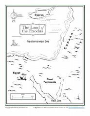
This “Land of the Exodus” Bible map will help kids learn where key places referenced in the story of the Exodus are located in relationship to each other and the broader region.
We don’t know the exact route taken by the Hebrew people as they traveled from Egypt, but we do know they crossed the Red Sea. Egyptian fortifications along the Mediterranean coast would have prevented a journey along the coast, which may partly explain why they took a more southern route to the Red Sea. It’s also probable that Moses was taking a route that would take them to Mt. Sinai in the most direct way.
The traditional location of Mt. Sinai is in the southern Sinai Peninsula, though we’re also uncertain about this. It was at Mt. Sinai that Moses received the Ten Commandments and Israel was effectively constituted as a new nation in a covenant relationship with their God, Yahweh.
From Mt. Sinai, the people would have traveled north toward Canaan. It was along the southern border of the Canaan Land that the people balked at God’s command to enter because of their unbelief. In response, God caused them to wander in the wilderness for 40 years until that faithless generation died off.
>You may want to show children a globe or world map as well so they can see where these lands fit in to the larger world geography. This map can be used as is for teaching or kids can color the map. (Product links are affiliate links.) A list of all of our maps is also on the site.
You can also see a list of the types of free, printable Bible activities we provide on the site.
For other related activities, see the links below.
- Related Activity Links:
- 10 Commandments, Divine Protection ,
- Moses ,
- Grade School (Readers), Preschool (Non-readers) ,
- God Gave Moses the Ten Commandments, God Led His People Through Moses, God Parted the Red Sea, God Spoke to Moses in the Burning Bush, God's People Enslaved In Egypt, God's People Wandered in the Wilderness, Moses and the Burning Bush, Moses and the Ten Commandments